
Atmosphere Cloud SaaS
Geospatial Project Management in the Cloud
Geospatial Project Management in the Cloud
GEOI Atmosphere SaaS is a data integration, data analytics and collaboration platform with an interactive map-based interface with intuitive dashboards. It allows users to organize, manage and administer their data based on projects and to seamlessly collaborate within their organization or externally to their clients. The Atmosphere Cloud self-serve SaaS technology platform arms and modernizes your organization with the next generation of collaborative geospatial project management and location-based mapping technology.
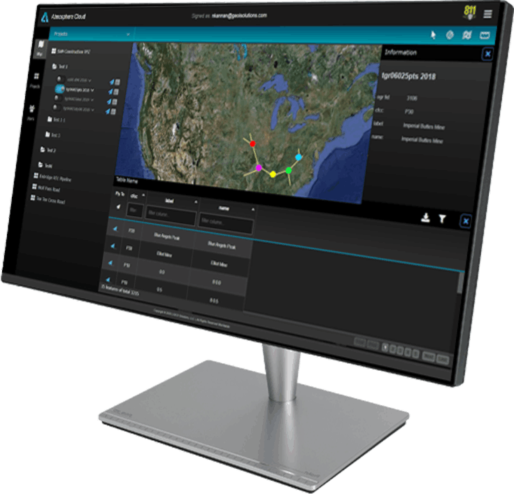
Atmosphere’s Geovisualization technology is a set of tools and techniques supporting Location Intelligence using interactive visualization. This includes interactive maps, time-based views, map-driven charts & reports, and schematic views of complex relationships. Our Geovisualization technology is accessible from many commercial handheld & mobile devices to web maps in browsers. It emphasizes on geospatial information in ways that, when combined with human understanding, allow for data exploration and enhanced decision-making processes

Atmosphere Cloud integrates your technology ecosystems by providing a data integration platform to bridge the gaps between different data sources and a myriad of data formats. Our technology integrates enterprise systems and eliminate data-silos.
Atmosphere makes sharing your data among project members easy and seamless. Teams can be set up in groups or as individuals. Only share what your users need to see. Set up project views and geo-project boundaries easily. Select project data layers and authorize permissions. It is simple and secure.
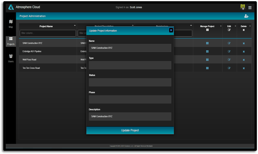
Atmosphere allows project administrators to easily manage data by organizing projects through a simple and intuitive management console. Administrators can create projects, map views, authorize users and manage project associated files. The administration console allows user authorization using various roles and permissions.
Atmosphere technology augments Location Intelligence (LI) to visualize and analyze relationships between spatial data sets to provide valuable insights. Our LI based data analytics extends Geographical Information Systems (GIS) tools to identify trends, patterns, and complex relationships to deliver actionable information that spans across multiple industries.

Atmosphere's Spatial Map Filtering allows you to refine your mapping experience, seeing individual portions of your data set, removing noise and outliers, and comparing how different factors can alter your data. Spatial Map Filtering extends all the existing features of Atmosphere, so you can tell rich and interactive stories using your map data. Quickly transform your data into a powerful and dynamic visual story.
Built with Mobirise css web theme